Trail Walking Le Monêtier-les-Bains - Chalet de l'Alpe - Grand lac - Croix 15/08/18 - Photo

Chalet de l'Alpe - Grand lac - Croix 15/08/18

 R@ph
R@ph

User GUIDE

© OpenStreetMap contributors
Length
Length
11.7 km
Max alt
Max alt
2430 m
Uphill gradient
Uphill gradient
767 m
Km-Effort
Km-Effort  
22 km
Min alt
Min alt
1711 m
Downhill gradient
Downhill gradient
760 m
Boucle
Boucle
Yes
Creation date :
2018-08-16 09:39:17.111
Updated on :
2018-08-16 10:07:46.462

(0 Reviews)

Walking
Walking
4h23
Difficulty : Medium

Scan this QR Code to open this trail in the SityTrail application

FREE GPS app for hiking

Logo SityTrail SityTrail

IGN / Geographical institutes

Download SityTrail from the App Store Download SityTrail from Google Play

Logo SityTrail SityTrail World

The world is yours!

Download SityTrail from the App Store Download SityTrail from Google Play Download SityTrail on Huawei AppGallery

About

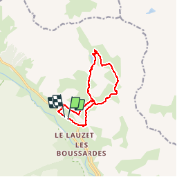
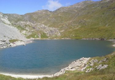
Trail Walking of 11.7 km to be discovered at Provence-Alpes-Côte d'Azur, Hautes-Alpes, Le Monêtier-les-Bains. This trail is proposed by R@ph.

Description

Au départ du Pont de l'Alpe, enfin presque c'est la galère pour stationner dans le secteur. Montée vers l'Alpe du Lauzet puis bifurcation à gauche sur la passerelle vers  le Grand Lac, une montée en lacets bien raide avant d'arriver au passage équipé de câble, sans grande difficulté. Vous sortez au sommet au niveau du Grand lac, monter ensuite vers le clos d'âne avec une vue magistrale. Puis redescente par l'autre versant jusqu'à l'Alpe du Lauzet. A partir de là j'ai choisi de revenir par le chemin du roy qui serpente en balcon au dessus de la vallée, ne pas louper la bifurcation qui permet de redescendre (bien raide) vers le parking.

Elevation profile

Photos

Positioning

Country:
France
Region :
Provence-Alpes-Côte d'Azur
Department/Province :
Hautes-Alpes
Municipality :
Le Monêtier-les-Bains
Location:
Unknown
Start:(UTM)
299954 ; 4988359 (32T) N.

Trails nearby

Trail Walking Le Monêtier-les-Bains - Le Grand Lac - Photo
Walking
tracegps

Walking

Difficult
(2)
Le Monêtier-les-Bains, Provence-Alpes-Côte d'Azur, Hautes-Alpes, France
5.2 km | 12.8 km-effort
5h 0min
No
Trail Walking Le Monêtier-les-Bains - Pic Blanc du Galibier - Photo
Walking
GUIDE
amiral13

Walking

Medium
Le Monêtier-les-Bains, Provence-Alpes-Côte d'Azur, Hautes-Alpes, France
4.3 km | 9.9 km-effort
2h 51min
Yes
Trail Walking Le Monêtier-les-Bains - pic est de Combeynot - Photo
Walking
GUIDE
amiral13

Walking

Very difficult
Le Monêtier-les-Bains, Provence-Alpes-Côte d'Azur, Hautes-Alpes, France
13.3 km | 33 km-effort
6h 24min
Yes
Trail Walking Le Monêtier-les-Bains - l'aiguillette du Lauzet par le grand lac - Photo
Walking
GUIDE
amiral13

Walking

Difficult
Le Monêtier-les-Bains, Provence-Alpes-Côte d'Azur, Hautes-Alpes, France
13.8 km | 29 km-effort
8h 39min
Yes
Trail Via ferrata Le Monêtier-les-Bains - Via ferrata Aiguillette du Lauzet 30/06/18 - Photo
Via ferrata
GUIDE
R@ph

Via ferrata

Medium
Le Monêtier-les-Bains, Provence-Alpes-Côte d'Azur, Hautes-Alpes, France
9.5 km | 21 km-effort
2h 30min
Yes
Trail Walking Le Monêtier-les-Bains - Haut tour des Cerces - Photo
Walking
druilhe

Walking

Very difficult
(1)
Le Monêtier-les-Bains, Provence-Alpes-Côte d'Azur, Hautes-Alpes, France
42 km | 77 km-effort
15h 27min
Yes
Trail Walking Le Monêtier-les-Bains - Le grand lac - Photo
Walking
GUIDE
amiral13

Walking

Medium
Le Monêtier-les-Bains, Provence-Alpes-Côte d'Azur, Hautes-Alpes, France
10.7 km | 20 km-effort
6h 15min
Yes
Trail Walking Le Monêtier-les-Bains - Lac du Glacier d'Arsine - Photo
Walking
patsure

Walking

Difficult
(1)
Le Monêtier-les-Bains, Provence-Alpes-Côte d'Azur, Hautes-Alpes, France
16.3 km | 29 km-effort
Unknown
Yes
Trail Touring skiing Le Monêtier-les-Bains - La pointe de L'etandard - Photo
Touring skiing
nadd73

Touring skiing

Medium
Le Monêtier-les-Bains, Provence-Alpes-Côte d'Azur, Hautes-Alpes, France
9.4 km | 27 km-effort
4h 3min
Yes


Close
My subscriptions